
The race to save glacial ice records before they melt away
When Margit Schwikowski helicoptered up to Switzerland’s Corbassière glacier in 2020, it was clear that things weren’t right. “It was very warm. I mean, we were at 4,100 meters and it should be sub-zero temperatures,” she says. Instead, the team started to sweat as they lugged their ice core drill around, and the snow was sticky. “I thought, ‘This has never happened before.’” What Schwikowski couldn’t see yet, but would find later in the lab, is that it wasn’t just the surface that was affected: Climate change had penetrated the ice and trashed its utility as an environmental record. Warming weather had created meltwater that trickled down, washing away trapped aerosols that researchers like her use as a historical record of forest fires and other environmental events. Because of the melt, she says, “we really lose this information.” Schwikowski, an environmental chemist at the Paul Scherrer Institut near Zurich, is the scientific lead for the Ice Memory Foundation, a collaborative group that aims to preserve glacial ice records before climate change wrecks them. Their goal is to get cores from 20 glaciers around the world in 20 years, and, starting in 2025, lock them away for long-term storage in an ice cave in the Antarctic — a natural freezer that will hold them at close to minus 60 degrees F (minus 50 degrees C). Since the program’s start in 2015 they have taken cores from eight sites, in France, Bolivia, Switzerland, Russia, Norway, and Italy. But the core attempted from Corbassière was a failure — and has the team wondering if they are already too late. The team, watching in despair as ice cores melt and muddle, is not alone in seeing climate change wreaking havoc with scientific records — often in unexpected ways. Geologists who hunt for meteorites on the ice in Antarctica are finding their mission thwarted by warming temperatures. And while archaeologists who study the artifacts spat out by ice patches are seeing a bonanza of new finds, they are also racing to get to those objects before they rot. Other heritage sites are slumping into thawing permafrost. What all these researchers have in common is a race to preserve what they can, while they can. When you are standing on a glacier that’s literally melting under your feet, says Schwikowski, “you really feel the urgency.” Researchers extract an ice core on an Ice Memory Foundation expedition to the Colle del Lys glacier in the Alps, October 2023. Riccardo Selvatico / CNR / Ice Memory Foundation Due to climate change, high mountain glaciers are now endangered, losing ice faster than they are gaining it. Studies of a few dozen well-monitored glaciers in the World Glacier Inventory have shown that the pace of glacial ice loss has accelerated from a few inches per year in the 1980s to nearly 3 feet per year in the 2010s. A 2023 model of some 215,000 mountain glaciers showed that nearly half of them could disappear entirely by 2100 if the world warms by just 1.5 degrees Celsius (2.7 degrees Fahrenheit), the ambitious maximum warming target of the Paris Agreement. Glaciers have annual layers, just like tree rings. At the top, a single year might see a few feet of snow added to the surface. Hundreds of feet down, weight compresses ice that is thousands of years old into thin, flowing layers, where less than an inch may contain a century of snowfall. This ice preserves all kinds of information from the time when it was deposited. A spike in lead pollution comes at the height of the Roman Empire. A drop in pollen reveals the collapse of farming during the Black Death. The Chernobyl accident left a layer of radioactive cesium. Black carbon and the sugars from burned cellulose map out changes in forest fire activity across the globe. The ratio of different oxygen and hydrogen isotopes in the water also reveals the air temperature of the time. Many mountain glaciers have been cored and studied over the past decades. Since scientific methods and research questions change over time, researchers preserve some cores or sections intact for future reference — to study, say, the genetics of ancient DNA. The National Science Foundation Ice Core Facility in Colorado, for example, holds 82,000 feet of collected ice cores — mostly from Greenland and the Antarctic, but also from North American mountaintop glaciers. The problem of glacial ice melting has been apparent for many years, says paleoclimatologist Ellen Mosley-Thompson of Ohio State University. In 2000, when she and her colleagues drilled to bedrock on Mount Kilimanjaro, they found the surface dated to the 1950s. The top 50 years of snow was gone. “Everyone in our community is worried,” she says. Read Next What your gut has in common with Arctic permafrost, and why it’s a troubling sign for climate change Sachi Kitajima Mulkey Dorothea Moser, a PhD student who works on the ice core chemistry team at the British Antarctic Survey, says she has seen cores damaged by melt even in polar regions, including Greenland and coastal Antarctica. “I’ve got records from Young Island [in the Southern Ocean] that have been heavily melt affected,” she says. She is now working to see what kinds of information can still be salvaged from corrupted cores. Moser warns that ice cores are highly vulnerable to increased melting through global warming. “This is why we need to retrieve them, where possible,” she says. In 2015, glaciologist Jérôme Chappellaz of the Swiss Federal Institute of Technology and chemist Carlo Barbante of the University of Venice established the Ice Memory Foundation to capture archival cores from endangered mountain glaciers. “Ice Memory is attempting to answer the call of these glaciers before they disappear,” says Mosley-Thompson, who is not a member of the foundation. Fewer than a dozen teams around the world do coring work in high mountain settings, says Schwikowski — it takes skill and determination to haul the equipment up to these remote locations, she says, often in collaboration with mountaineers. Progress has been slow. And, just halfway into their collection effort, the work at Corbassière has shown it may already be too late to get pristine records from some sites. The team only retrieved around 60 feet of core from Corbassière, rather than the 260 feet down to bedrock that they had hoped for, because the drill got stuck in melted-and-refrozen ice. And a comparison of this truncated 2020 core with a 2018 sample from the same spot showed that the record was corrupted. While the temperature record was preserved, the spikes of nitrate, sulfate, and ammonia they had seen in the 2018 core had, by 2020, washed away. The team thinks the cumulative effect of meltwater is to blame. Deeper ice may or may not be damaged, too. Margit Schwikowski holds an ice core from the Corbassière glacier in the Alps, September 2020. Scanderbeg Sauer Photography The team has no idea how many other glaciers are affected: A core that the group took more recently from Svalbard in Norway was similarly muddled, says Schwikowski, while one taken from Monte Rosa in the Alps in 2021 seems to be intact. “I am afraid that most of them are already affected,” she says. “We will see what we can do.” The loss of paleorecords in glacial ice is also distressing to archaeologists, who use those signals to help unravel the behaviors of past societies and the environmental conditions they faced. Of course, archaeologists also have another category of study material: human artifacts. To find these, they often look to ice patches — wind-blown snow drift accumulations that can be thousands of years old. Christian Thomas, an archaeologist with the Yukon Territory’s Department of Tourism and Culture, says such patches typically overlap with traditional summer hunting grounds, so ancient weapons are often found there. The first documented find from an ice patch was an arrow in Norway during a particularly warm year in 1914. Discoveries were only random and occasional until the 1990s, when such finds sped up along with the rate of ice melt, says Lars Holger Pilø, co-director of the Secrets of the Ice program at Norway’s Department of Cultural Heritage. “We had no idea how intense the human use of the high mountains had been until all these artifacts started to emerge from the retreating ice,” he says. “In that way, we are unlikely beneficiaries of global warming.” Since Pilø started his own work in 2006, he says the number of finds and sites has exploded, from a few hundred finds and less than 10 sites in 2006 to more than 4,000 finds from 69 sites in 2023. Some objects date back 6,000 years. They have found more arrows, clothing (including a 1,700-year-old Iron Age tunic and a 3,400-year-old Early Bronze Age shoe), and even prehistoric skis. Such items are often in pristine condition, “frozen in time,” says Pilø. “But once they become exposed to the elements, the clock starts ticking fast, and they will [decompose and] be lost if they are not found and conserved.” “Our ice patch sites are considered imperiled,” says Thomas, who doesn’t expect the ones in the Yukon to survive the next 20 to 30 years. Both in the Yukon and in Norway, scientists are on a quest to collect archaeological finds as quickly as possible. Read Next A new satellite could help solve one of our climate’s biggest mysteries: Clouds Syris Valentine While markers of human history are being erased, other researchers are worried, too, about access to markers of the solar system’s history: meteorites. These inch-sized chunks of the moon, Mars, or the asteroid belt contain vital evidence about the elemental composition of celestial objects and their origins. These rocks fall to Earth everywhere but are easiest to spot against white snow. Hundreds of meteorites fall over the vast surface of the Antarctic each year, and, over millennia, this has built up to an estimated stock of 300,000 to 850,000 space rocks sitting out on the ice. Researchers typically go out and collect about 1,000 a year, from “blue ice” fields where the meteorites are brought to the surface by ice flow and where no fresh snow falls to hide them. Glaciologists Harry Zekollari and Veronica Tollenaar of the Université libre de Bruxelles set out to map the best places to hunt for these rocks, using an artificial intelligence model. Their work revealed that temperature is a major factor determining where meteorites can be found. The reason is simple: black rocks absorb heat from the sun. Even a brief spate of 16 degrees F (minus 9 degrees C) is warm enough for a meteorite to melt the snow beneath it, says Tollenaar, allowing it to sink — just as gravel thrown onto an icy driveway will drill down into tiny holes during the heat of the day. The team estimates that some 5,000 meteorites sink out of sight this way each year and that every tenth of a degree Celsius of warming adds an additional 5,000 to the loss. By the end of the century, they predict, some 25 to 75 percent of the meteorites sitting on Antarctic ice could disappear from view, taking scientific information with them. The Ice Memory Foundation is continuing on its mission to gather and store ice cores. But it’s hard going. Trips planned to take a core from Kilimanjaro in 2022, and in Tajikistan more recently, both fell through, says Schwikowski — it can be difficult to coordinate the necessary permits, people, and funding to get up these mountains and take samples away. The team does have permission to store their ice cores in the Antarctic. This November they plan to ship a balloon to Concordia Station, the French-Italian research base in East Antarctica, where it will be blown up and snow piled on top to make an ice cave big enough to drive into. The ice cores are due to be shipped there at the end of 2025, where they will be stored in insulated boxes to keep the temperature steady. Such a cave should be stable for at least a decade, after which another, similar cave can be built if needed. A 1,200-year-old birch distaff found near the shrinking Lendbreen ice patch in Norway. Espen Finstad / Secrets of the Ice Of course, you don’t have to go to the Antarctic to find cold. There are plenty of freezers capable of maintaining such low temperatures, including the National Science Foundation ice core facility in Denver. But Schwikowski points out that these facilities use energy and are vulnerable to temperature fluctuations and even failure. In 2017, a rare double malfunction caused the Canadian Ice Core Archive freezer in Alberta to warm up to around 100 degrees F (40 degrees C) without triggering the right alarms. Several valuable core sections melted. In a separate event, Thomas says that they, too, lost ice when walk-in freezers in the Yukon failed. Aside from logistical considerations, says Schwikowski, there’s a beauty to storing this ice in a place that sits outside of national ownership: “The Antarctic is a continent of peace and research.” She just hopes to get to the mountain glaciers quickly enough to store their ice. “It worries me a lot,” she says. “We are not so fast. It is not easy.” This story was originally published by Grist with the headline The race to save glacial ice records before they melt away on Jul 14, 2024.
As glaciers melt around the globe, scientists are racing to retrieve ice cores that contain key historical records of temperature and climate that are preserved in the ice.
When Margit Schwikowski helicoptered up to Switzerland’s Corbassière glacier in 2020, it was clear that things weren’t right. “It was very warm. I mean, we were at 4,100 meters and it should be sub-zero temperatures,” she says. Instead, the team started to sweat as they lugged their ice core drill around, and the snow was sticky. “I thought, ‘This has never happened before.’”
What Schwikowski couldn’t see yet, but would find later in the lab, is that it wasn’t just the surface that was affected: Climate change had penetrated the ice and trashed its utility as an environmental record. Warming weather had created meltwater that trickled down, washing away trapped aerosols that researchers like her use as a historical record of forest fires and other environmental events. Because of the melt, she says, “we really lose this information.”
Schwikowski, an environmental chemist at the Paul Scherrer Institut near Zurich, is the scientific lead for the Ice Memory Foundation, a collaborative group that aims to preserve glacial ice records before climate change wrecks them. Their goal is to get cores from 20 glaciers around the world in 20 years, and, starting in 2025, lock them away for long-term storage in an ice cave in the Antarctic — a natural freezer that will hold them at close to minus 60 degrees F (minus 50 degrees C). Since the program’s start in 2015 they have taken cores from eight sites, in France, Bolivia, Switzerland, Russia, Norway, and Italy. But the core attempted from Corbassière was a failure — and has the team wondering if they are already too late.
The team, watching in despair as ice cores melt and muddle, is not alone in seeing climate change wreaking havoc with scientific records — often in unexpected ways. Geologists who hunt for meteorites on the ice in Antarctica are finding their mission thwarted by warming temperatures. And while archaeologists who study the artifacts spat out by ice patches are seeing a bonanza of new finds, they are also racing to get to those objects before they rot. Other heritage sites are slumping into thawing permafrost.
What all these researchers have in common is a race to preserve what they can, while they can. When you are standing on a glacier that’s literally melting under your feet, says Schwikowski, “you really feel the urgency.”

Due to climate change, high mountain glaciers are now endangered, losing ice faster than they are gaining it. Studies of a few dozen well-monitored glaciers in the World Glacier Inventory have shown that the pace of glacial ice loss has accelerated from a few inches per year in the 1980s to nearly 3 feet per year in the 2010s. A 2023 model of some 215,000 mountain glaciers showed that nearly half of them could disappear entirely by 2100 if the world warms by just 1.5 degrees Celsius (2.7 degrees Fahrenheit), the ambitious maximum warming target of the Paris Agreement.
Glaciers have annual layers, just like tree rings. At the top, a single year might see a few feet of snow added to the surface. Hundreds of feet down, weight compresses ice that is thousands of years old into thin, flowing layers, where less than an inch may contain a century of snowfall.
This ice preserves all kinds of information from the time when it was deposited. A spike in lead pollution comes at the height of the Roman Empire. A drop in pollen reveals the collapse of farming during the Black Death. The Chernobyl accident left a layer of radioactive cesium. Black carbon and the sugars from burned cellulose map out changes in forest fire activity across the globe. The ratio of different oxygen and hydrogen isotopes in the water also reveals the air temperature of the time.
Many mountain glaciers have been cored and studied over the past decades. Since scientific methods and research questions change over time, researchers preserve some cores or sections intact for future reference — to study, say, the genetics of ancient DNA. The National Science Foundation Ice Core Facility in Colorado, for example, holds 82,000 feet of collected ice cores — mostly from Greenland and the Antarctic, but also from North American mountaintop glaciers.
The problem of glacial ice melting has been apparent for many years, says paleoclimatologist Ellen Mosley-Thompson of Ohio State University. In 2000, when she and her colleagues drilled to bedrock on Mount Kilimanjaro, they found the surface dated to the 1950s. The top 50 years of snow was gone. “Everyone in our community is worried,” she says.

Dorothea Moser, a PhD student who works on the ice core chemistry team at the British Antarctic Survey, says she has seen cores damaged by melt even in polar regions, including Greenland and coastal Antarctica. “I’ve got records from Young Island [in the Southern Ocean] that have been heavily melt affected,” she says. She is now working to see what kinds of information can still be salvaged from corrupted cores.
Moser warns that ice cores are highly vulnerable to increased melting through global warming. “This is why we need to retrieve them, where possible,” she says.
In 2015, glaciologist Jérôme Chappellaz of the Swiss Federal Institute of Technology and chemist Carlo Barbante of the University of Venice established the Ice Memory Foundation to capture archival cores from endangered mountain glaciers. “Ice Memory is attempting to answer the call of these glaciers before they disappear,” says Mosley-Thompson, who is not a member of the foundation.
Fewer than a dozen teams around the world do coring work in high mountain settings, says Schwikowski — it takes skill and determination to haul the equipment up to these remote locations, she says, often in collaboration with mountaineers. Progress has been slow. And, just halfway into their collection effort, the work at Corbassière has shown it may already be too late to get pristine records from some sites.
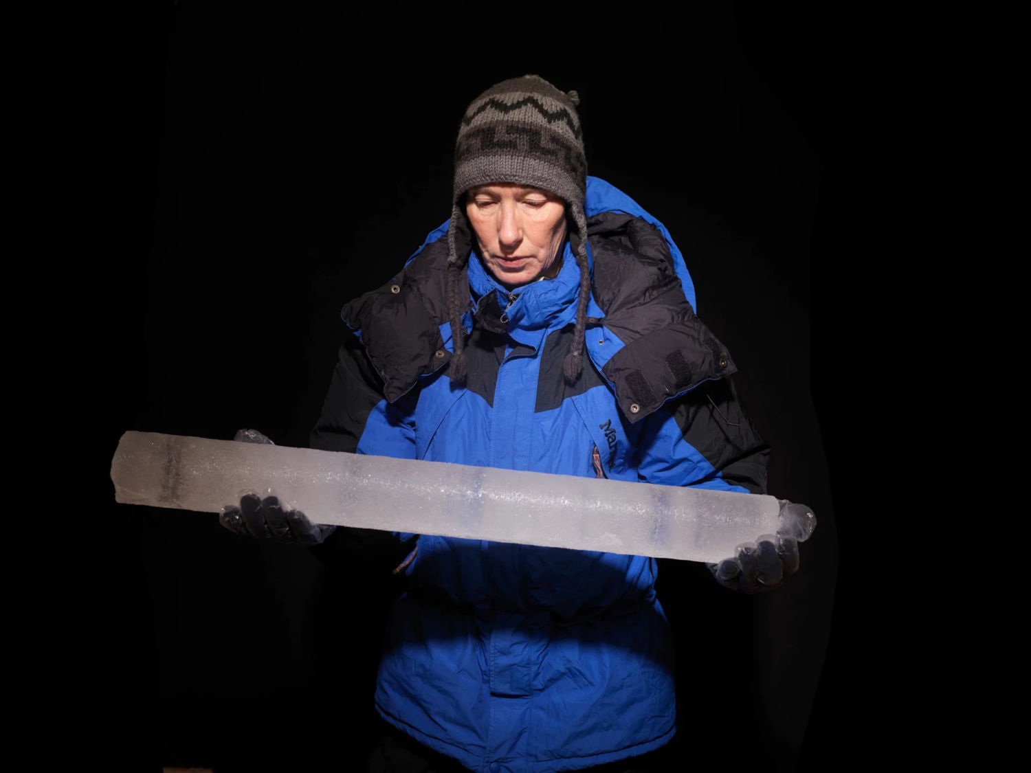
The team only retrieved around 60 feet of core from Corbassière, rather than the 260 feet down to bedrock that they had hoped for, because the drill got stuck in melted-and-refrozen ice. And a comparison of this truncated 2020 core with a 2018 sample from the same spot showed that the record was corrupted. While the temperature record was preserved, the spikes of nitrate, sulfate, and ammonia they had seen in the 2018 core had, by 2020, washed away. The team thinks the cumulative effect of meltwater is to blame. Deeper ice may or may not be damaged, too.

The team has no idea how many other glaciers are affected: A core that the group took more recently from Svalbard in Norway was similarly muddled, says Schwikowski, while one taken from Monte Rosa in the Alps in 2021 seems to be intact. “I am afraid that most of them are already affected,” she says. “We will see what we can do.”
The loss of paleorecords in glacial ice is also distressing to archaeologists, who use those signals to help unravel the behaviors of past societies and the environmental conditions they faced. Of course, archaeologists also have another category of study material: human artifacts. To find these, they often look to ice patches — wind-blown snow drift accumulations that can be thousands of years old. Christian Thomas, an archaeologist with the Yukon Territory’s Department of Tourism and Culture, says such patches typically overlap with traditional summer hunting grounds, so ancient weapons are often found there.
The first documented find from an ice patch was an arrow in Norway during a particularly warm year in 1914. Discoveries were only random and occasional until the 1990s, when such finds sped up along with the rate of ice melt, says Lars Holger Pilø, co-director of the Secrets of the Ice program at Norway’s Department of Cultural Heritage. “We had no idea how intense the human use of the high mountains had been until all these artifacts started to emerge from the retreating ice,” he says. “In that way, we are unlikely beneficiaries of global warming.”
Since Pilø started his own work in 2006, he says the number of finds and sites has exploded, from a few hundred finds and less than 10 sites in 2006 to more than 4,000 finds from 69 sites in 2023. Some objects date back 6,000 years. They have found more arrows, clothing (including a 1,700-year-old Iron Age tunic and a 3,400-year-old Early Bronze Age shoe), and even prehistoric skis. Such items are often in pristine condition, “frozen in time,” says Pilø. “But once they become exposed to the elements, the clock starts ticking fast, and they will [decompose and] be lost if they are not found and conserved.”
“Our ice patch sites are considered imperiled,” says Thomas, who doesn’t expect the ones in the Yukon to survive the next 20 to 30 years. Both in the Yukon and in Norway, scientists are on a quest to collect archaeological finds as quickly as possible.

While markers of human history are being erased, other researchers are worried, too, about access to markers of the solar system’s history: meteorites. These inch-sized chunks of the moon, Mars, or the asteroid belt contain vital evidence about the elemental composition of celestial objects and their origins. These rocks fall to Earth everywhere but are easiest to spot against white snow. Hundreds of meteorites fall over the vast surface of the Antarctic each year, and, over millennia, this has built up to an estimated stock of 300,000 to 850,000 space rocks sitting out on the ice. Researchers typically go out and collect about 1,000 a year, from “blue ice” fields where the meteorites are brought to the surface by ice flow and where no fresh snow falls to hide them.
Glaciologists Harry Zekollari and Veronica Tollenaar of the Université libre de Bruxelles set out to map the best places to hunt for these rocks, using an artificial intelligence model. Their work revealed that temperature is a major factor determining where meteorites can be found. The reason is simple: black rocks absorb heat from the sun. Even a brief spate of 16 degrees F (minus 9 degrees C) is warm enough for a meteorite to melt the snow beneath it, says Tollenaar, allowing it to sink — just as gravel thrown onto an icy driveway will drill down into tiny holes during the heat of the day.
The team estimates that some 5,000 meteorites sink out of sight this way each year and that every tenth of a degree Celsius of warming adds an additional 5,000 to the loss. By the end of the century, they predict, some 25 to 75 percent of the meteorites sitting on Antarctic ice could disappear from view, taking scientific information with them.
The Ice Memory Foundation is continuing on its mission to gather and store ice cores. But it’s hard going. Trips planned to take a core from Kilimanjaro in 2022, and in Tajikistan more recently, both fell through, says Schwikowski — it can be difficult to coordinate the necessary permits, people, and funding to get up these mountains and take samples away.
The team does have permission to store their ice cores in the Antarctic. This November they plan to ship a balloon to Concordia Station, the French-Italian research base in East Antarctica, where it will be blown up and snow piled on top to make an ice cave big enough to drive into. The ice cores are due to be shipped there at the end of 2025, where they will be stored in insulated boxes to keep the temperature steady. Such a cave should be stable for at least a decade, after which another, similar cave can be built if needed.

Of course, you don’t have to go to the Antarctic to find cold. There are plenty of freezers capable of maintaining such low temperatures, including the National Science Foundation ice core facility in Denver. But Schwikowski points out that these facilities use energy and are vulnerable to temperature fluctuations and even failure. In 2017, a rare double malfunction caused the Canadian Ice Core Archive freezer in Alberta to warm up to around 100 degrees F (40 degrees C) without triggering the right alarms. Several valuable core sections melted. In a separate event, Thomas says that they, too, lost ice when walk-in freezers in the Yukon failed.
Aside from logistical considerations, says Schwikowski, there’s a beauty to storing this ice in a place that sits outside of national ownership: “The Antarctic is a continent of peace and research.” She just hopes to get to the mountain glaciers quickly enough to store their ice. “It worries me a lot,” she says. “We are not so fast. It is not easy.”
This story was originally published by Grist with the headline The race to save glacial ice records before they melt away on Jul 14, 2024.